 |
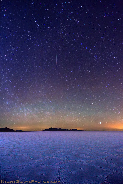
| Big Dipper stars and meteor over Bonneville Salt Flats, Utah ~ © Royce Bair |
Trying to find a sky dark enough to reveal the stars in the night sky can be challenging when you live near a large city. The high light pollution from the city lights overpowers all but the brightest stars. For this reason, I often drive west of Salt Lake City, where I live, and into to the west desert. The famous Bonneville Salt Flats are located about 90 miles west of SLC, just off of I-80, about 10 miles before you reach the border town of Wendover, Nevada. In the above photo, I was able to capture a meteor during the Quadrantid meteor shower, as it streaked between the Big Dipper and Polaris.
How far away from the city lights does one have to travel to find skies dark enough to photograph the stars? Typically, I tell people that you must be about 50 to 75 miles (80 to 120 km) from a large city (over 100,000 population), and 5 to 10 miles (8 to 16 km) from a smaller town (under 10,000). That can be difficult in many of the populated areas of the world.
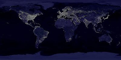 |
| The Earth at Night - "Earth's Lights" - a composite satellite image from NASA |
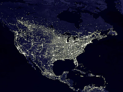 |
| Here's a closer view of just North and Central America |
A Useful Tool: A more scientific approach is to use a website I found recently called, "
Dark Sky Finder". Jonathan Tomshine has incorporated light pollution information from the NOAA National Geophysical Data Center and layered it over Google Maps! Here a screenshot of the Salt Lake City metro area and the desert area, west to Wendover, NV. (If you click and enlarge the map, you can see the Bonneville Salt Flats along I-80, just before you get to Wendover.):
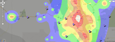 |
| Dark Sky Finder screenshot of SLC metro and west desert to Wendover, Nevada |
The color coding indicates the sky darkness of area: the white and red layers over the city center are pretty much "white-out" areas! The orange areas over the city suburbs aren't much better. These areas allow one to barely see only the brightest stars. The yellow areas have somewhat acceptable viewing conditions. The green areas are acceptable for star photography, but the blue and dark grey areas are best. As with all Google maps, you can toggle between this "Map" view and the "Satellite" and "Hybrid" view. Unfortunately, the NOAA light pollution data is only available for the USA.
Technical data for the top photo: The
NightScape of the stars over the Bonneville Salt Flats was taken on January 4, 2011 at 3:45 A.M with a
Canon EOS 5D Mark II camera, using a
Canon EF 15mm f2.8 Fisheye lens @ f3.5, 30 seconds, ISO 2500.
Find Darkness in a High Population Area: Check out
this article about photographer, Jack Fusco, and how he overcame the challenges of light pollution in New Jersey!
Royce Bair is the editor of this blog and the photographer of the top image. Here is my gallery of
NightScape images. My schedule of workshops, tutorials, and other events is available
here.


Looking for a dynamic social media agency in Delhi? We specialize in crafting compelling digital strategies to elevate your brand presence across platforms like Instagram, Facebook, LinkedIn, and more. Our expert team offers services ranging from content creation, influencer collaborations, and performance marketing to analytics-driven campaigns.
ReplyDeleteWe focus on engaging storytelling and targeted ad strategies that resonate with your audience and boost ROI. Whether you're a startup or an established enterprise, we tailor solutions to suit your unique goals. With a proven track record and deep industry insight, we turn followers into loyal customers. Let's transform your brand's social media impact—contact us today!
Really I am very impressed with this post. Just awesome, I haven’t any word to appreciate this post dark sky
ReplyDeletePlanning a memorable celebration starts with the right atmosphere, and professional lighting can completely transform your venue Affordable Event Lighting Packages Cliffside Park are perfect for weddings, birthdays, corporate gatherings, sweet 16 parties, and private events looking to create an elegant and energetic experience without exceeding the budget.
ReplyDeleteFrom uplighting and dance floor lighting to custom monograms and LED effects, modern lighting solutions help enhance décor, highlight key event areas, and keep guests engaged throughout the celebration. Professional event lighting adds warmth, sophistication, and excitement while matching your event theme and color palette perfectly.
Affordable lighting packages in Cliffside Park often include setup, breakdown, wireless lighting systems, and customizable options designed to fit both small and large venues. Whether you want a romantic ambiance for a wedding reception or vibrant party lighting for a birthday event, experienced lighting specialists can deliver the perfect setup tailored to your vision.
Choosing professional event lighting services ensures high-quality equipment, smooth coordination, and stress-free execution on your special day. With flexible packages and creative lighting designs, you can elevate your event and create unforgettable memories for your guests in Cliffside Park.
For More Info:
Call Now: 973-705-4445
Email: Info@mixnitupevents.com